Posts

Showing posts from 2010

Surveying Walden Pond | Thoreau

Image
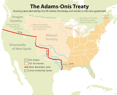
In the book for which he is famous, Henry Thoreau writes, "Desirous to recover the long lost bottom of Walden Pond, I surveyed it carefully, before the ice broke up, early in '46, with compass and chain and sounding line." But the sole reason Thoreau gives for his survey-that he wanted to make sure the pond had a bottom-is intentionally misleading. Sounding the depths of the pond was only a part, perhaps the simplest part, of an ambitious task with profound justifications. This task, along with almost everything about the extensive surveying work Thoreau did in his lifetime, deserves a closer look. For starters, it seems essential to know how Thoreau actually made the Walden survey, a three-dimensional pond map that is now one of the most important images in American literary history. Surveying the sixty-one-acre pond presented significant technical challenges, but it was also a physically arduous process requiring days, perhaps weeks of toil. Chopping more than a hundred

Why Oklahoma is shaped the way it is? Part 2 – The Panhandle

Image
One of the most unique features of the shape of our State is known as the Panhandle. The Panhandle of Oklahoma has its own history somewhat separate from the rest of the State. In Part 1 of this series “The South and West Borders” we learned how the western boundary of the main body of Oklahoma was created. Well quite simply, that (western border) line is the eastern border of the Panhandle. It was part of what was then Texas. To learn about the southern boundary of the Panhandle we must talk about the Northern boundary of Texas. When Texas was admitted to the Union in 1845, its Northern border was established as 36 degrees and 30 minutes north latitude from 100 degrees west longitude to 103 degrees west longitude. However, when the South Line of Kansas was created in by the Kansas-Nebraska Act of 1854 it was established at 37 degrees north latitude thus leaving a one-half degree (30 minutes of latitude) strip of land from the western boundary of the main body of Oklahoma all the

Why Oklahoma is shaped the way it is? Part 1 – The South and West borders

Image
Oklahoma is one of the most uniquely shaped states in the union. Its shape is the result of some of the most important historical treaties and documents in our country’s history. The first boundaries of our state were established by the Louisiana Purchase of 1803. However those boundaries were not clearly defined until the Adams-Onis treaty of 1819. ARTICLE 3 of the Adams-Onis treaty reads as follows: The Boundary Line between the two Countries, West of the Mississippi, shall begin on the Gulf of Mexico, at the mouth of the River Sabine in the Sea, continuing North, along the Western Bank of that River, to the 32d degree of Latitude; thence by a Line due North to the degree of Latitude, where it strikes the Rio Roxo of Nachitoches, or Red-River, then following the course of the Rio-Roxo Westward to the degree of Longitude, 100 West from London and 23 from Washington, then crossing the said Red-River, and running thence by a Line due North to the River Arkansas, thence, following

What Is Geocaching?

Image
Geocaching is a hi-tech version of treasure hunting that requires the use of handheld Global Positioning System (GPS) receivers. The basic idea is to have individuals and organizations establish and maintain cache locations and publish the coordinate location of the caches on a website such as geocaching.com. A cache is a water-proof container that typically contains a log book, pencil and small pencil sharpener as well as a supply of trinkets and trade items. The treasurer hunter will visit www.geocaching.com and select caches they would like to find. When they find the cache, they sign the log book and may trade comparable items. Some people are in it just for the thrill of the hunt and may write "TNLN" in the logbook, a common notation for "Took nothing, left nothing". You can learn more about Geocaching at www.geocaching.com   Geocachers use GPS to find and set things that are not obvious to the eye. Land surveyors also use GPS (among lots of other cool and

April 19, 1995

Image
As we approach the 15th anniversary of the bombing of the Alfred P. Murrah Federal Building we are all forced unwittingly to remember that terrible day in Oklahoma City history. In fact, using the word anniversary seems inappropriate but I don’t know what other word to use so I will use it with a lower case “a” I worked for the same Engineering and Surveying firm that I do now. We had our offices on 50th and Pennsylvania near 50 Penn Place, about 4 miles away. That morning at 9:02 I was on the phone with a client and our building shook and the all-glass building rattled like someone had run into it. We all heard it and felt it but didn’t know what it was until a few minutes later in the break room. I can recall the first image I saw was brought to me from KWTV’s Kelly Ogle, who is also a lifelong Oklahoman. Kelly was in the Channel 9 chopper and flew over the smoke filled rubble and said “it looks like half the building was gone”. It was. Kelly first though it may have been a gas

The Last Ride

Image
Today I lost my best friend of 13 years. Joker was a beautiful Australian Shepherd but most of all he was an unconditional friend. He taught me many things but one of the most important was no matter how bad you may have it you always treat your friends the same, with unconditional love. He taught me that holding grudges was a waste of time and energy. If you treat your friends and family the same every time, you will earn their respect. Joker didn’t get off to a great start in our family because we didn’t know anything about dogs. We quickly learned. If he had been a person he might have given up on us and moved on to another family but he knew we that he could train us, and he did. We soon learned that having a dog wasn’t having something to control, it was someone to share your life and experiences with. After we realized what is was about, Joker seemed to say “I knew you would come around”. After that, he, my wife and I were inseparable. He loved to chase the horses. I’d bet h

The Initial Point

Image
All land in Oklahoma, with the exception of the Panhandle, is surveyed from the Initial Point located in Murray County. When Ft. Sill was established in 1870, the U.S. cavalry stationed at Ft. Arbuckle was moved there. Since the fort belonged to the U.S. Government, it was a perfect base of operations for the survey crew. The Initial Point was established in 1870 by Ehud N. Darling and Theodore H. Barrett. Darling was surveying the lands for the Chickasaw and Choctaw Nations as described in the Treaty of June 22, 1855. By the treaty of April 28, 1866, these Indians agreed to the survey and subdivision of their land east of the 98th meridian, using the public land survey system of the United States, called the Land Ordinance of 1785 or the Rectangular System. The 1871 report of the Commissioner of the general Land Office contains the following statement: "The surveyors were instructed to select a suitable initial point in the center of the Chickasaw Nation or in the vici