The Initial Point
All land in Oklahoma, with the exception of the Panhandle, is surveyed from the Initial Point located in Murray County. When Ft. Sill was established in 1870, the U.S. cavalry stationed at Ft. Arbuckle was moved there. Since the fort belonged to the U.S. Government, it was a perfect base of operations for the survey crew.
 The Initial Point was established in 1870 by Ehud N. Darling and Theodore H. Barrett. Darling was surveying the lands for the Chickasaw and Choctaw Nations as described in the Treaty of June 22, 1855. By the treaty of April 28, 1866, these Indians agreed to the survey and subdivision of their land east of the 98th meridian, using the public land survey system of the United States, called the Land Ordinance of 1785 or the Rectangular System.
The 1871 report of the Commissioner of the general Land Office contains the following statement: "The surveyors were instructed to select a suitable initial point in the center of the Chickasaw Nation or in the vicinity of Ft. Arbuckle and perpetuate it by a suitable monument, and from this point to establish a principle meridian and base line to be known by the designation of the Indian Base Line and Meridian."
The point chosen was about one mile of Ft. Arbuckle probably because Ft. Arbuckle was a convenient and well know location. The land was then divided into townships north and south and ranges, east and west of the Initial Point. From this point, they plotted the location of rivers, streams, mountain ranges, wagon roads and trails. Each township and range is six miles, or a total area of 36 square miles. In Oklahoma, there are 29 townships north and south and twenty seven ranges east and west of the Initial Point. In Oklahoma, Sections 16 and 32 were normally reserved for schools.
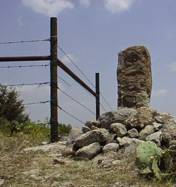
The official description of the arbitrary point, taken from the surveyor's, field notes is:
 "Initial monument at point between two small streams both having a northerly course, making a junction about twenty chains north."Set sandstone 54x18x18, marked on west side I. P., on east side Ind. Mer., and on north side 1870, in a mound of stones six feet in diameter and three feet high, from which flagstaff at Fort Arbuckle bears north seven degrees, thirty-seven minutes west. East end of Messa, bears north 46 degrees, 17 minutes west. East end of Messa bears north 47 degrees, 42 minutes west. East end of Messa bears north 55 degrees, 56 minutes west. Black oak 10 inches in diameter bears north 70 degrees, 11 minutes west 617 links distant. Rock on east side of brook marked thus (111) bears south 14 degrees, 12 minutes east, 1,365 links distant. Cedar eight inches in diameter just left of rock."
The Initial Point was established in 1870 by Ehud N. Darling and Theodore H. Barrett. Darling was surveying the lands for the Chickasaw and Choctaw Nations as described in the Treaty of June 22, 1855. By the treaty of April 28, 1866, these Indians agreed to the survey and subdivision of their land east of the 98th meridian, using the public land survey system of the United States, called the Land Ordinance of 1785 or the Rectangular System.The 1871 report of the Commissioner of the general Land Office contains the following statement: "The surveyors were instructed to select a suitable initial point in the center of the Chickasaw Nation or in the vicinity of Ft. Arbuckle and perpetuate it by a suitable monument, and from this point to establish a principle meridian and base line to be known by the designation of the Indian Base Line and Meridian."
The point chosen was about one mile of Ft. Arbuckle probably because Ft. Arbuckle was a convenient and well know location. The land was then divided into townships north and south and ranges, east and west of the Initial Point. From this point, they plotted the location of rivers, streams, mountain ranges, wagon roads and trails. Each township and range is six miles, or a total area of 36 square miles. In Oklahoma, there are 29 townships north and south and twenty seven ranges east and west of the Initial Point. In Oklahoma, Sections 16 and 32 were normally reserved for schools.
The official description of the arbitrary point, taken from the surveyor's, field notes is:
"Initial monument at point between two small streams both having a northerly course, making a junction about twenty chains north."Set sandstone 54x18x18, marked on west side I. P., on east side Ind. Mer., and on north side 1870, in a mound of stones six feet in diameter and three feet high, from which flagstaff at Fort Arbuckle bears north seven degrees, thirty-seven minutes west. East end of Messa, bears north 46 degrees, 17 minutes west. East end of Messa bears north 47 degrees, 42 minutes west. East end of Messa bears north 55 degrees, 56 minutes west. Black oak 10 inches in diameter bears north 70 degrees, 11 minutes west 617 links distant. Rock on east side of brook marked thus (111) bears south 14 degrees, 12 minutes east, 1,365 links distant. Cedar eight inches in diameter just left of rock."
Comments
Post a Comment