Why Oklahoma is shaped the way it is? Part 1 – The South and West borders
Oklahoma is one of the most uniquely shaped states in the union. Its shape is the result of some of the most important historical treaties and documents in our country’s history.
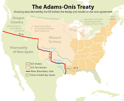
The first boundaries of our state were established by the Louisiana Purchase of 1803. However those boundaries were not clearly defined until the Adams-Onis treaty of 1819.
ARTICLE 3 of the Adams-Onis treaty reads as follows:
The Boundary Line between the two Countries, West of the Mississippi, shall begin on the Gulf of Mexico, at the mouth of the River Sabine in the Sea, continuing North, along the Western Bank of that River, to the 32d degree of Latitude; thence by a Line due North to the degree of Latitude, where it strikes the Rio Roxo of Nachitoches, or Red-River, then following the course of the Rio-Roxo Westward to the degree of Longitude, 100 West from London and 23 from Washington, then crossing the said Red-River, and running thence by a Line due North to the River Arkansas, thence, following the Course of the Southern bank of the Arkansas to its source in Latitude, 42.Click here to read the entire text of the Adams-Onis Treaty of 1819
The Adams-Onis Treaty of 1819 defined the southern and western borders of the main body of the state as we know it today.

One of the main controversies of this boundary came after Texas joined the Union and it became necessary to define the boundaries between Texas and Oklahoma. An expedition was commissioned to explore and map the Red River (southern boundary of Oklahoma) as indicated by the original treaty. However, before the expedition reached the 100th meridian as instructed in the treaty, they unknowingly diverted onto the North Fork of the Red River instead of the holding to the main stream of the Red River. This error resulted in the lands now known as Greer County (south and west of the North Fork) to be assumed in Texas until the U.S. Supreme Court settled the issue placing the boundary in its rightful location, thus “returning” Greer County to Oklahoma. Of course, it was never truly in Texas to begin with.

Map courtesy of the Oklahoma Historical Society
Would you happen to know how they chose the point of origin?
ReplyDeleteBy the way, I like your blog! I enjoy learning new things all the time, especially the things they don't cover in school anymore. I have you in my newsreader. :-)
Don't be dissapointed but it was pretty much random. The instructions were to select a spot near the Fort (Arbuckle) on a high spot to begin the surveys. And so they did.
ReplyDelete