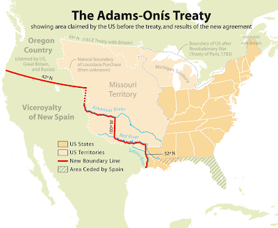
Why Oklahoma is shaped the way it is? Part 1 – The South and West borders

Oklahoma is one of the most uniquely shaped states in the union. Its shape is the result of some of the most important historical treaties and documents in our country’s history. The first boundaries of our state were established by the Louisiana Purchase of 1803. However those boundaries were not clearly defined until the Adams-Onis treaty of 1819. ARTICLE 3 of the Adams-Onis treaty reads as follows: The Boundary Line between the two Countries, West of the Mississippi, shall begin on the Gulf of Mexico, at the mouth of the River Sabine in the Sea, continuing North, along the Western Bank of that River, to the 32d degree of Latitude; thence by a Line due North to the degree of Latitude, where it strikes the Rio Roxo of Nachitoches, or Red-River, then following the course of the Rio-Roxo Westward to the degree of Longitude, 100 West from London and 23 from Washington, then crossing the said Red-River, and running thence by a Line due North to the River Arkansas, thence, following ...
