Posts

Showing posts from June, 2015

10 Simple Rules for Writing eMail

Image
The days of communicating face to face or even over the phone are slowing fading away. Electronic mail has become the main form of communication in our society. Anyone remember hand-writing letters? Of course you don’t unless you're 90. The sad thing is that if we did remember when we hand-wrote letters, maybe our eMail communications would be better today. I guess what I’m saying is try to use etiquette for eMail similar to hand-writing a letter but not as short (or stupid) as texting. Our society has become so “immediate gratification” and “instant notification” that we often don’t slow down and make sense when we compose eMail. eMail shouldn’t be written like texting, Twitter or Facebook (those are a whole other level of communication). I probably receive or write 50-100 emails a day and I have seen some of the worst and the best. Here are a few rules that you can follow to make the experience better for you and the recipient. Most of these are business related but stil

Surveying in a [non] Perfect World

Image
A lot of people mistakenly think surveying is a perfect science with exact measurements. Well, it isn’t. Yes, we can make exact measurements but that is not the science behind the profession. That is just the technology . Nowhere does this appear more often than when an unqualified person writes a new legal description for a portion of a previously described tract of land. Such as the “ South one-half of Lot 2 ” That looks like a fairly straightforward description until someone wants to sell the remainder of Lot 2 to someone else. Lot 2 is platted as 100’ wide so the second [unqualified] person writes the descriptions as the “ North 50’ of Lot 2 ” Probably thinking to themselves “ Hey I will make this description even better and super-duper accurate ” The problem Is, Lot 2 was laid out in 1970 and never surveyed on the ground. When it is finally surveyed, Lot 2 is found to only be 99.5’ feet wide in real life. So the “ South one-half ” is really only 49.75 feet and the “ No

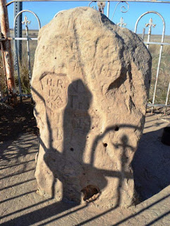
The Cimarron Meridian and Base Line (Panhandle)

Image
In an earlier blog I discussed the Initial Point , which is the origin for the majority of surveys in the State of Oklahoma. The exception being the Panhandle, which has its own history and point of origin for the surveys that followed after it became part of Oklahoma Territory. “The public land strip which is included in said territory of Oklahoma, is bounded by the one hundredth meridian, south by Texas, west by New Mexico, north by Colorado and Kansas”   excerpt from the Organic Act of 1890 Eventually, there would be a need to lay out the lands into sections and quarter sections just as the “main body” of Oklahoma was done. The “other” Initial Point was too far away to serve as a sufficient starting point for the surveys, so a new starting point was established just for this small strip of Oklahoma. The starting point (Cimarron Meridian and Base Line) was determined to be located at the intersection of 103 degrees of west longitude (meridian) and 36 degrees and 30 minu