The Cimarron Meridian and Base Line (Panhandle)
In an earlier blog I discussed the Initial Point, which is
the origin for the majority of surveys in the State of Oklahoma. The exception
being the Panhandle, which has its own history and point of origin for the surveys
that followed after it became part of Oklahoma Territory.
“The
public land strip which is included in said territory of Oklahoma, is bounded by
the one hundredth meridian, south by Texas, west by New Mexico, north by Colorado
and Kansas” excerpt from the Organic
Act of 1890
Eventually, there would be a need to lay out the lands into
sections and quarter sections just as the “main body” of Oklahoma was done. The
“other” Initial Point was too far away to serve as a sufficient starting point for
the surveys, so a new starting point was established just for this small strip
of Oklahoma.
The starting point (Cimarron Meridian and Base Line) was determined
to be located at the intersection of 103 degrees of west longitude (meridian) and
36 degrees and 30 minutes north latitude (base line). This is the point from
which all lands in the Panhandle are described.
When you see a legal description
such as; Section 12, Township 3 North, Range 15 East of the C.M. that is based off the Cimarron Meridian and puts it in
Texas County near Guymon, OK.
When you see a legal description such
as; Section 12, Township 3 North, Range 15 East of the I.M. that is based off the Indian Meridian and puts it in Pittsburg County, south of
McAlester, OK
 |
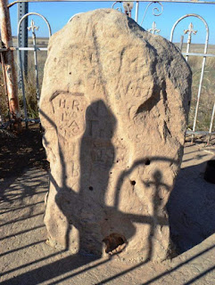
| Chaney / Smith Monument 1881 |
So those last two letters in a legal description make a big
difference. Of course if the county name is mentioned then it is more obvious
which meridian is being referenced.
The starting point has now been created but there is a
bigger problem, locating that point on the ground accurately so that the
surveys of the Panhandle can commence. The most difficulty arose from locating
the 103rd west longitude line.
The first attempt was made in 1857 by General Joseph E.
Johnston but placed the location of the 103rd too far west by about
4.4 miles.
The second attempt was made in 1859 by Captain J.N McComb.
They only missed the mark by about 2.5 miles too far west (getting closer!)
Finally, the 103rd meridian was accurately surveyed
by Richard Chaney and William W. Smith in 1881. What was different this time?
TIME!
The biggest key to surveyors and astronomers locating a line
of longitude accurately was being able to accurately determine the time of day.
Being able to obtain an accurate time in the field was not easy in the mid 1800’s
and thus created the two erroneous locations of the 103rd meridian.
 |
| Cimarron Meridian and Base Line 1932 |
With the railroad expanding west, came the telegraph line which
allowed the surveyors to have access to the accurate time needed to make solar
observations and determine once and for all the location of the 103rd
Meridian and the west line of the Panhandle of Oklahoma.
There was also some difficulty in locating the 36º 30’ line of latitude. Even
though Chaney and Smith were ultimately successful in locating the 103rd
meridian, they weren’t so successful in locating the 36º 30’ line of latitude. The monument they established
was later determined to be slightly north of 36º
30’. However, their monument remained as the marking of the starting point of
futu
 |
| State Line between OK Panhandle and Texas 1932 |
Because of this slight discrepancy in the location of the
base line vs. the true line of 36º
30’, there was a small strip of land that caused question about the location of
the state line between Texas and the Oklahoma panhandle. This conflict was eventually
settled in 1932 resulting in a small strip of land lying SOUTH of the Cimarron
Base Line belonging to Oklahoma.
Confusing? Yes. But that is surveying in what is the piece-meal
state we call Oklahoma!
Comments
Post a Comment