Posts

Showing posts from 2015

10 Simple Rules for Writing eMail

Image
The days of communicating face to face or even over the phone are slowing fading away. Electronic mail has become the main form of communication in our society. Anyone remember hand-writing letters? Of course you don’t unless you're 90. The sad thing is that if we did remember when we hand-wrote letters, maybe our eMail communications would be better today. I guess what I’m saying is try to use etiquette for eMail similar to hand-writing a letter but not as short (or stupid) as texting. Our society has become so “immediate gratification” and “instant notification” that we often don’t slow down and make sense when we compose eMail. eMail shouldn’t be written like texting, Twitter or Facebook (those are a whole other level of communication). I probably receive or write 50-100 emails a day and I have seen some of the worst and the best. Here are a few rules that you can follow to make the experience better for you and the recipient. Most of these are business related but stil...

Surveying in a [non] Perfect World

Image
A lot of people mistakenly think surveying is a perfect science with exact measurements. Well, it isn’t. Yes, we can make exact measurements but that is not the science behind the profession. That is just the technology . Nowhere does this appear more often than when an unqualified person writes a new legal description for a portion of a previously described tract of land. Such as the “ South one-half of Lot 2 ” That looks like a fairly straightforward description until someone wants to sell the remainder of Lot 2 to someone else. Lot 2 is platted as 100’ wide so the second [unqualified] person writes the descriptions as the “ North 50’ of Lot 2 ” Probably thinking to themselves “ Hey I will make this description even better and super-duper accurate ” The problem Is, Lot 2 was laid out in 1970 and never surveyed on the ground. When it is finally surveyed, Lot 2 is found to only be 99.5’ feet wide in real life. So the “ South one-half ” is really only 49.75 feet and the “ No...

The Cimarron Meridian and Base Line (Panhandle)

Image
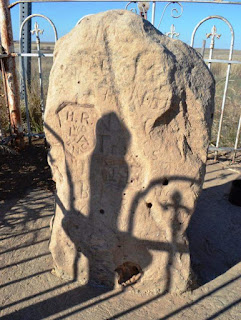
In an earlier blog I discussed the Initial Point , which is the origin for the majority of surveys in the State of Oklahoma. The exception being the Panhandle, which has its own history and point of origin for the surveys that followed after it became part of Oklahoma Territory. “The public land strip which is included in said territory of Oklahoma, is bounded by the one hundredth meridian, south by Texas, west by New Mexico, north by Colorado and Kansas”   excerpt from the Organic Act of 1890 Eventually, there would be a need to lay out the lands into sections and quarter sections just as the “main body” of Oklahoma was done. The “other” Initial Point was too far away to serve as a sufficient starting point for the surveys, so a new starting point was established just for this small strip of Oklahoma. The starting point (Cimarron Meridian and Base Line) was determined to be located at the intersection of 103 degrees of west longitude (meridian) and 36 degrees and 30 ...

The Last 50 years

Image
My wife and I were talking about our grandpas the other day and how much change they must have seen in their lifetime. I thought about it and I believe the last 50 years may have given us more change than the 50 years before that 10 things I use every day that weren't around then: Zenith Space Commander 300 TV Remote GPS (Can you imagine telling a 20-something to read a map?) TV Remote control (My dad used to call his “Burk”) Intermittent windshield wipers. (Before this, they were either on or off) Smoke detectors (before these, people just died) Digital Cameras (you had to go to the drug store to see your pictures) Microwave (maybe if you were rich in 1975) Electronic payments /ATM’s (cash, what a novel idea) Cell Phones Personal Computers THE INTERNET (Probably the biggest game changer)

My First Food Review – Empire Slice House

Image
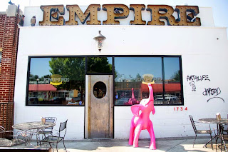
I normally don’t do food reviews. Mainly because I love all things food, so what’s the point? Today I made my 10 th trip to the Empire Slice House in the Plaza District of Oklahoma City with a great friend of mine. He bought, so that’s why he is a GREAT friend, not just a GOOD friend. There are lots of new trendy hipster restaurants popping up all over OKC and, frankly, this is one of them. But what makes Empire Slice House different? They got it right ! Yes, they are in the trendy part of town with trendy wait staff (aka awesome wait staff) but the main reason is they got it right . They serve pizza, really good pizza and beer. That’s it! Oh sure, they have the obligatory salad or something like that for all the healthy eaters out there. But mainly they serve really good pizza at a really good price, and beer The one non-pizza/beer item that is a must-try is the garlic knots; garlic bread dripping in butter with marinara sauce.  If you are here, you are probably ...

Do you survey with Computers?

Image
In some form or another, I have been asked this question more times than you think. So I want to take a minute to clarify a little about technology and Land Surveying. Gunters Chain and early compass Technology has been changing in the survey industry ever since the first transits were built. Even more so in the last 20 years than the 150 years prior to that. The profession of Land Surveying, however, has remained basically the same since the beginning of time. We locate and mark the boundaries of land. The technology involved in making those decisions is irrelevant. It is just a tool to measure distance and angles. I have heard people use technology as a “crutch” to say something like “the property corners moved because we can measure better today”. Property corners don’t move. When we are asked to locate the boundaries of a parcel of land, we have to consider the means of measurement that were in place at the time of the original survey. It’s what we call in our prof...

9:02: A New anniversary, A New Generation

Image
It is hard to believe that another five years have passed. Five years ago I wrote about the 15th anniversary of the bombing of the Alfred P. Murrah Federal Building.  Today we mark the 20th year since that horrible day. As we get further and further away from that fateful day in history, I am reminded of the importance of telling the story to the next generation so they don't forget. Tell them about where you were. Tell them about the people you knew that were lost. Tell them everything you know Oklahoma City National Memorial & Museum We were talking about this at the office the other day as most Oklahoman's do around April of each year. My assistant was with us and I commented that she wasn't even born yet when the bombing happened. Even though that statement was true, she reminded me that even her history is tied to this fateful day. You see, her mother went into labor with her on April 19, 1995. A great resource for history and information about the bom...

Is Your Business Card Stupid?

Image
I am designing some new business cards for myself and I realized that Land Surveyors have some of the worst, most UN-unique business cards I have ever seen. Some look like they are printed on a color printer in their office and cut-up with scissors. They all seem to have a tripod or a north arrow or some kind of compass. BLAH! Before you fire off and say that business cards are a thing of the past, let me continue. I won’t disagree that business cards are not as critical as they once were in the business world. However, that doesn't mean they are obsolete. Think of them as a mini marketing brochure that you carry around in your pocket. Granted most people will enter your info in their smart phone and toss the card, or maybe they won’t. If your card isn't stupid. Make your card unique and maybe they might leave it lying on their desk and show other people. One thing for sure, in this competitive market, you need to take advantage of every marketing tool at your dispos...

How much does a survey cost?

Image
I get asked this question more times than “ Why do Surveyors never Agree ?” I won’t spend a huge amount of time on the issue but I will try to explain why there is no answer to this question, at least not initially. By comparison, this question is about the same as asking “how much does a house cost?” First and foremost Land can be described in many ways. Section/Township/Range , Metes and Bounds or Lot and Block or any combination of the three. Land descriptions that are referenced to Section/Township/Range in the Public Land System can be more expensive to survey because the underlying portion of the section must also be surveyed thus increasing the cost. If the description is an aliquot (proportional) part such as the SW/4 or the N/2, it can be even more expensive because the entire underlying Section must be surveyed. Land described by metes and bounds can be less expensive to survey because only the portion of the parent parcel that is referenced needs to be surveyed. ...