Posts

Showing posts with the label surveying

Oklahoma Land Descriptions

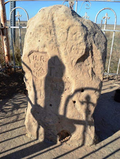
Have you ever wondered what all of those letters and numbers on your deed description mean? Or why most of the roads in Oklahoma are one mile apart? This is the first in a series of articles to familiarize you with the system by which we convey your most valuable commodity, your land. In the late 1800’s government surveyors were commissioned to lay out the public lands (Oklahoma Territory) into a grid in preparation for sale or grant to the public. These grids were to be 6 miles square and were known as townships. They would be later divided into 36 smaller units, which are our modern day sections of 640 acres each. In most areas they were then divided into even smaller squares or Quarter Sections (160 acres). Iron posts were set at the corners of the townships and stones were placed at all of the section and quarter corners. Some of these stones can still be found today if the area is wooded or otherwise has not been disturbed. The point of origin of these sections is known as the...

Why do surveyors never agree?

I get asked this question more than any other when someone finds out that I am a surveyor. Well there isn’t an easy answer but I thought I would try to explain it the best I can. Surveying is like investigating a crime scene, the more evidence you find the more likely you will arrive at the correct solution. If you don’t gather ANY evidence you are basically guessing the outcome. If you gather evidence for weeks before making your decision you will likely come up with a different solution than someone who investigated for only a few days. I know, take it easy there CSI-okie! However, the similarities are actually quite common. Evidence that surveyors gather might be historical. Some of it might be mathematical. Some of it might even be biological. But all of it combined, will lead to a more certain solution. Let’s say that a CSI investigating a crime didn’t have access to a certain eyewitness than another CSI did have access to. The first solution is not going to be as cer...

Surveyor | Short Film

Image
Intriguing anti-western by first time director Scott Blake. A story of a government surveyor circa 1848 on a trek home after surveying land on the Western frontier. It's a highly accomplished period piece with meticulous attention to detail re: costumes, props, location. A rare formalist feat by a young filmmaker who appears to have no interest in the rickety realism he has every right making at his age, 26. Surveyor may require a little patience - it begins minimally and is long for a short at 25 minutes - but it's far from stagnant, and includes a notable last minute pivot into hallucinatory darkness. What begins as a rigorous exercise unfolds like a gothic nightmare - you can't quite make sense of it all, but it feels real. Impressive and mysterious debut film [Watch in full screen mode for better quality video]

Surveying in a [non] Perfect World

Image
A lot of people mistakenly think surveying is a perfect science with exact measurements. Well, it isn’t. Yes, we can make exact measurements but that is not the science behind the profession. That is just the technology . Nowhere does this appear more often than when an unqualified person writes a new legal description for a portion of a previously described tract of land. Such as the “ South one-half of Lot 2 ” That looks like a fairly straightforward description until someone wants to sell the remainder of Lot 2 to someone else. Lot 2 is platted as 100’ wide so the second [unqualified] person writes the descriptions as the “ North 50’ of Lot 2 ” Probably thinking to themselves “ Hey I will make this description even better and super-duper accurate ” The problem Is, Lot 2 was laid out in 1970 and never surveyed on the ground. When it is finally surveyed, Lot 2 is found to only be 99.5’ feet wide in real life. So the “ South one-half ” is really only 49.75 feet and the “ No...

The Cimarron Meridian and Base Line (Panhandle)

Image
In an earlier blog I discussed the Initial Point , which is the origin for the majority of surveys in the State of Oklahoma. The exception being the Panhandle, which has its own history and point of origin for the surveys that followed after it became part of Oklahoma Territory. “The public land strip which is included in said territory of Oklahoma, is bounded by the one hundredth meridian, south by Texas, west by New Mexico, north by Colorado and Kansas”   excerpt from the Organic Act of 1890 Eventually, there would be a need to lay out the lands into sections and quarter sections just as the “main body” of Oklahoma was done. The “other” Initial Point was too far away to serve as a sufficient starting point for the surveys, so a new starting point was established just for this small strip of Oklahoma. The starting point (Cimarron Meridian and Base Line) was determined to be located at the intersection of 103 degrees of west longitude (meridian) and 36 degrees and 30 ...

Do you survey with Computers?

Image
In some form or another, I have been asked this question more times than you think. So I want to take a minute to clarify a little about technology and Land Surveying. Gunters Chain and early compass Technology has been changing in the survey industry ever since the first transits were built. Even more so in the last 20 years than the 150 years prior to that. The profession of Land Surveying, however, has remained basically the same since the beginning of time. We locate and mark the boundaries of land. The technology involved in making those decisions is irrelevant. It is just a tool to measure distance and angles. I have heard people use technology as a “crutch” to say something like “the property corners moved because we can measure better today”. Property corners don’t move. When we are asked to locate the boundaries of a parcel of land, we have to consider the means of measurement that were in place at the time of the original survey. It’s what we call in our prof...

Trespass and Surveyors

Image
The trespass Statute in Oklahoma (OS Title 21 Chapter 70 Section 1835.2) has needed some work since it was passed in 2006. I am not sure of the history of 1835.2 but it somewhat conflicts with 1835. 1835 gives Land Surveyors in the performance of their duties immunity from criminal trespass. Something that is necessary for us to meet the State Minimum Standards for Land Survey ing. In 2006, Section 1835.2 was passed which still protected us from criminal trespass although adding a paragraph which lists a group a people that must leave the property if asked to do so orally or in writing. They include: Registered land surveyors in the performance of their professional services Registered professional engineers in the performance of their professional services  persons making a delivery  persons selling a product or service  persons conducting a survey or poll persons working on behalf of a candidate for political office  Now maybe I am just ov...

My Fence = My property line

Image
This is one of the most common misconceptions among landowners today. In an earlier blog I wrote about evidence that surveyors use to retrace a boundary location. Fences certainly can be part of that evidence. That does not mean, however, that a landowner should assume that a fence is built on the property line. Fences have been built for many reasons, containing livestock or pets, providing a visual barrier, even just plain ol’ decoration. Sometimes a fence may be built to mark a boundary line but my experience says this is more often the exception than the rule. Many properties have utility easements or building setback lines along their perimeter and fences are often built along those lines instead of the actual property line. If you didn’t personally build the fence in question, it would be better to assume that it is NOT on the property line. At least that way you won’t get yourself into trouble later for building your fence on the adjoiner’s property. Many landow...

Surveying Walden Pond | Thoreau

Image
In the book for which he is famous, Henry Thoreau writes, "Desirous to recover the long lost bottom of Walden Pond, I surveyed it carefully, before the ice broke up, early in '46, with compass and chain and sounding line." But the sole reason Thoreau gives for his survey-that he wanted to make sure the pond had a bottom-is intentionally misleading. Sounding the depths of the pond was only a part, perhaps the simplest part, of an ambitious task with profound justifications. This task, along with almost everything about the extensive surveying work Thoreau did in his lifetime, deserves a closer look. For starters, it seems essential to know how Thoreau actually made the Walden survey, a three-dimensional pond map that is now one of the most important images in American literary history. Surveying the sixty-one-acre pond presented significant technical challenges, but it was also a physically arduous process requiring days, perhaps weeks of toil. Chopping more than a hundred...